Alaska - Canada hitchhiking tour 23.7.-29.9.2009
Allright, here it is my long promised Alaska-Canada trip report!
I just got back to Germany on Tuesday, classes started on Wednesday and I am still trying to adjust back into school mode...still I sometimes wake up in the morning, not knowing where I am...kind of when I woke up sometimes in the last few weeks when I had to figure out where I went to sleep the last night before...but this was part of the fun beeing out there, not knowing where I will be the next day and always meeting new interesting people along the way.
Enjoy the amazing scenery, read along my stories and give me a feedback by droping a comment or two on how you like it!

Picture taken from my 13 hours long flight, just after an 1 hour layover in Whitehorse, Canada where the plane droped up and picked up some passengers before heading on to Fairbanks, Alaska, USA. During the flight I got to know another German guy called Benjamin, he kind of had the same idea of travelling through Alaska and so we hooked up with each other.


After we left the airport in Fairbanks we walked to the place where I arranged through couchsurfing.com a place to stay for 2 nights. We stayed in this 'old' house with 3 students that study at the local university. None of them where there when we go there around 3pm but they left the door open for us and so we could make ourselves at home.


After a night without any darkness, here in Fairbanks they have 23 hours of sunlight during some parts of the summer. A thing which really made it hard for me to get over my jetlag....but we still made it to check out the city, which wasn´t too attractive at all...


time to get out 'into the wild', in order to get there we took the bus to get outside of the city and from there our hitchhiking adventure started within not even 10 minutes holding out our thumbs and sign.


First destination was the Chena Hot Springs Park, around 100km north-east of fairbanks. There we went on the Chena Dome Trail, a 29 miles long ridge hike along the peaks above the tree line.


on the second day we soon found out that there was no water on the trail, even though promised by the park rangers and guide book. well so we were hiking with 2 liters each per day for 2 days. So on day 3 we had to make a choice, either keep on going along the ridge another 10 miles to the end of the trail or going down a trail, almost 600 metres of elevation to fill up on water in a creek on the bottom of the valley below us. Well we went down but also had to go back up because there was no way out along the valley. Alaska is one of these countries where you don´t find a lot of hiking trails....


well back up on the trail we enjoyed the luxury of having enough water and so we drank and cooked some pasta. tonight benjamin was cooking the dinner.


while I was fighting the bugs...most evenings I wore this mosquito net on my head and long sleeved pants and shirts...


day 4, we walked the last few miles out back to the park road, and there we discovered a old log built cabin and restaurant in where we got ourselves some burgers and cold coke. While eating we got into a talk with another man in there, he was a helicopter pilot working for a gold mine company that was digging for gold out there somewhere in the mountains. he told us his story of when he was in our age, hitch hiking across the states and alaska. so after he fell in love with this country he moved over here from the netherlands... then when we were going to pay we got told that he already paid for us...man how lucky can you be?!


the luck stuck with us for the rest of the day, after we left the restaurant we got a ride within 30 seconds. Next stop was up the road at the dead end where the Chena Hot Springs are, here we went into the hot water, soacked our aching bodies and had some time to relax. After the hot springs we tried to get back to fairbanks, our driver this time was Greg, probably one of the most interesting man I ever met in my whole life. Just a great guy with great stories, and even though he was a rich man he didn´t show anything from it, stayed on the ground and had a great view of this world and how we´re supposed to live in it. So the time (3 hours) back to fairbanks just flew by so quickly and we had to let him move on his own ways...we stayed the night on a local campground before moving south along the Richardson Highway on the next morning.


it took us quite some time to get a ride out of the fairbanks area but once we were out there it was easy to keep going, here you can see benjamin trying his luck just before we got picked up by a 19 years old girl which was part of the US army stationed down in Delta Junction, her dad was driving behind her on his motorbike and promised her to kill us in case we would harm her along the way...


this picture was taken from a sacred mountain south of Delta Junction along the Richardson HWY, there we set up camp for the night.


climbing up the sacred mountain, which is still used as a ceremonial site by the local native people


in the distance, we could see the Alaska Range with it´s high mountains, some of them the highest in North America


the next morning we moved on down south, our driver this time was a 'private' gold prospector, he drives all over Alaska during the summer, saves some sites where he thinks there could be gold and then goes back to the Lower 48 (mainland USA), checks if the sites are on government land or not and if yes he comes back the next year to start digging for gold. Actually he makes a living of this kind of work...


...if you look at the truck he was driving you might suggest not the best living...haha but up in Alaska nobody cares about the look of your truck, house or clothes you wear!


We got droped of in Paxson, here is the junction with the Denali HWY, a 200km gravel road across the wilderness to the George Parks HWY and also the Denali National Park. This road is only open during summer months and not maintained during the winter, which is pretty long as you can see on the sign in this picture.


took us quite some time to catch a ride on this gravel road, about 2 cars in one hour makes it hard to hitch hike, finally we got picked up by a german family in their motorhome. great people but the ride was only 20 miles long to Tangle Lake. Instead of staying on the road we decided to spent there the night as well.


next morning we got picked up by a young man and his dad on the way to Cantwell. they drove a pick up truck and we could sit in the open back of it. first it was fun, but the chilly wind turned this into a cold fun experience...haha we ended up wearing our hat, jackets and still feeling cold in the back of the truck. but the scenery along the way made up for this and we had one of the best rides in our lifes. wide open country, wild rivers, mountains, glaciers, ice fields and nobody else around.


3 hours later we told our drivers we want to get droped off here at Brushkana Creek, if we would have kown that it would take us 3 hours to catch the next ride the next day we might have kept on going with the two guys in the pick up truck...


after half a day on the road we arrived in the Denali National Park, there we got our backcountry permits, park bus ticket and food containers. the last bus brought us out to the backcountry unit 4 where we had a permit to stay for the first night. this park is all about permissions...but good thing is they regulate the numbers that can stay out there, which helps to keep this huge area wild and full of wildlife.


5am, we had to get back to the park road to catch the first camper bus further into the national park


the pictures speak for itself, beautiful sceneries, valleys, canyons, mountains, rivers and so on. on the way in we saw a couple of eagles soaring above the road, 2 grizzly bears, cariboos, moose...


and here she comes, the mighty Mount Mc Kinley, also known as Denali Mountain, North America´s highest mountain and usually covered in clouds. But we were lucky and could see him 3 days in a row during our time in the park backcountry


it´s hard to capture it´s size on a picture, but the 'foothill-mountains' in front of it are 3000metres high...


we spent the rest of our backcountry time in unit 32, accessible by a wide river bed divided by several arms of the glacier fed river. first day we tried to go up to a mountain lake. going up along a creek turned out to be very rough and later impossible because of too much thick bushes, and trees in our way. so we went back down to the river bed, a fairly safe place to stay for the night. next morning we saw these two mooses feeding close to our tents.


we planed to scale another mountain the next day across the river, so after several crossings of the river arms we looked back and found out that this grizzly bear was following us just 30metres behind us. he also crossed the river, luckily after we made enough noise he kept on going his own way upstream.


we set up camp on the foot of cabin mountain, while hiking up the mountain we saw a wolfe going through our campsite a few hundred meters below us, first we thought it was a bear but when the wolfe checked out our food and later sniffed on my tent we realized it was too small for a bear...it could have been a bear as well and so after we scaled the peak we went back down into the river valley which seemed to be a much safer place for the night because we could see much further and were not on game trails which crossed the mountains.


the last day we spent walking back out to the park road, took a bus to the end of the road and then took the same bus back out of the park. There we split up because we wanted to try to go our own ways from here on. we spent almost two weeks together and had a good time on the road and in the wilderness.


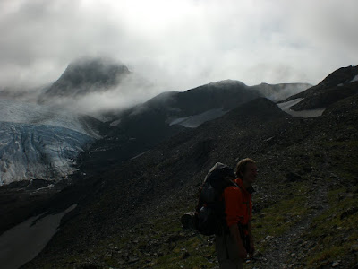
the same day, around 7pm I caught a ride down the George Parks HWY to Eagle River, a suburb town of Anchorage. There I spent a night and restocked my food, hitchhiked to the Crowe Pass trailhead and got to know two guys from the states. because of a supposedly dangerous river crossing along the trail we hooked up for the hike. Next day we came to the river crossing, high waters because of the heavy last night´s rain and warm temeperatures which melted the glacier ice. Half way through the river we couldn´t feel our legs anymore, the water was waist high, freezing cold with chunks of glacier ice flowing in it´s strong currents...good part of the story...we made it across and after 15 minutes we could also feel our legs again.


the we hiked up the crowe pass, up a big valley and even the sun came out, which was nice since we´ve been hiking in rain since we left the trailhead.


another night on the trail just below the glacier with a cold skinny diping bath in a small creek with a nice water bowl


here already descending down the trail on the other side of the mountain, the clouds just came up from the valley which made up for a spectacular show of clouds and mountains


once we got down to girdwood, a small town along the Turnagain Arm, we dried our stuff in the sun, took a 6$ shower in a laundromat store and then caught two rides all the way to the Girdwood Trail trailhead from Cooper Landing to Hope. We decided to continue on this hike together since we got along pretty well and had about the same hiking pace.
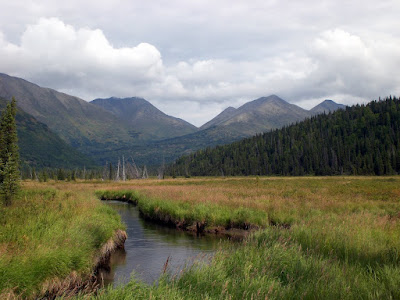

the trail wasn´t that challenging as the last one we did, but still nice scenery along the trail and good times in the evenings with a campfire and usually nobody else besides us around


the valley we hiked through was loaded with blueberries, and so we used them for breakfast...fresh berries with oatmeal...exactly the stuff that gets you going for another day on the trail with a heavy backpack


on our last day on the trail we came to a river loaded with salmons, it was the salmon run which started when we were there. we talked about gettign some fish before and so we tried out luck here. I got this one with my hiking pole, yes you read right, stabbed him right through with my pole and then got him out of the water. well then we had the problem of processing the fish in an area also loaded with bears that came down to the water for catching salmon, and I had a big salmon loaded in my backpack...guess what how fast we were trying to hike to the next place were we could make a fire to BBQ our big catch. oh and so good the salmon, just a little pepper, salt and fresh garlic on the salmon made us a delicious lunch.


My two new friends didn´t have that much time as I had and moved on to Seward, myself I stayed a night in Hope, small village which was left over from the gold rush days and now mostly habitated by people that hate the big city and chose to live out here in this little community of 180 people.


Jim and his daughter took me out fishing on their boat for a day, I became friends with them while staying next to them on the local campground. great people which I will keep in my memories of alaska! hope I can visit them sometimes in the future....


After 3 days in Seward I hitchhiked to Whittier, once built as a secret US military bas but now a small village with 80 people, mostly old, artists and people that work on the fishing industry. bad weather forced me to move on with the ferry...


when I got to Valdez it was still raining, even the next day it hadn´t stoped and so I decided to move on towards better weather...I tried to get closer to canada...


got picked up along the Tok Cut Off HWY by an older man who had a house and a cabbin back in the woods where he let me stay as long as I wanted, I stayed for a night. Enjoyed the wood stove and blueberries but also moved on the next day because the rain caught up with me again...


In Tok, close to the border to canada I tried to get a ride up the Top of the world HWY, but the weather was so crappy that nobody except one young women with a baby and a car full of stuff went up there. so I ended up to get picked up by a couple from the states. they took me across the border, helped me to convince the border official to let me in and then even offered me to stay with them for the night on a campground.


the next day we stoped at the Kluane National Park for a little hike and then they took me all the way to Haines Junction where they decided to go west and I wanted to go east to Whitehorse. On the way to there I realized that O must have left my camera in their van, but these great people found out my email address, tried to get in touch with me and even sent my camera to a friend´s place in vancouver...otherwise all these pictures would have been gone...! GREAT to knwo that there are still AMAZING people out there that care for each other! Thanks Susan and Christian!


in Whitehorse I slept one night in a hostel, my first night in a real bed under a roof after almost 5 weeks...in whitehorse I spent some time in the city but soon felt like it was time to move on, so after a last walk along the Yukon river I moved on along the Alaska HWY.


5 hours down the road my driver droped me off around 9pm, checked out the sign forest here and then found a nice place at a small lake for the night


the next morning I had a few coffees at the local grocery store, a bunch of locals where there as well. I got to know them a little bit, heard some stories of hitchhikers that got stuck here in Watson Lake for up to 5 days, knowing this I went back out to the HWY, but not even 10 minutes later I had a ride from Tom in his nice old VW van, I shared my trailmix with him and he returned the favor by stoping and brewing some tea for us on his camping stove, another one of these easy going people I was able to get to know along the way.


I asked Tom to drop me off at the Liard Hot Springs Provincial Park, there I soaked my body for 2 hours before trying to catch another ride. It took me almost 2 hours, the bugs were really bad here because of all these hot mineral springs and I ended up trying to catch a ride with my mosquito net on my head....and I got a ride! A semi truck driver on his way home to Edmonton picked me up...


through some of the best parts of the Alaska HWY, Stony Mountain Park and other small protected areas.


After 2 days on the road with him we got to Fort St. John, there I had a place to stay with friends of mine.


The Bidulka family lives 20km outside of Fort St. John and make their living with farming. They tried to do everything to make my stay with them a great experience, they introduced me to their community pasture and the couple that takes care of it.


Next stop, just 3 hours down the Alaska HWY was Beaverlodge, my friend Lee lives there out in the woods with his family in the cooles log house I´ve ever seen. Had a great time with them and I even had the chance to go fishing with Lee at the Wapiti river


the first hour or so I was still able to hike along a fairly good trail but then I got to a point where there was no more trail, all grown over, sometimes there were some game trail which were leading into the right direction but soon also stoped to go further through the bushes. So after 2 hours of intense bushwacking I decided to turn around and walk back to Maligne Lake. Made it even all the way back to Jasper where I spent a night on the campground.


Hiking down the Parks HWY wasn´t that easy since it´s a toll road and mostly used by tourists. Well but some of them do pick up people like me, first ride was with a guy who was on a two year moving trip from England to New Zealand and my second one was with a couple from Belgium in their rented motorhome. First thing they did when I got onto their vehicle was they offered me a fresh cold beer! AWESOME RIDE!


They even let me stay with them on a campground outside of Calgary, shared their dinner with me and listened excitedly to my stories! My pland was to get to Lethbridge, souteast of Calgary, in a day. Getting through and out of Calgary was a tough job since hitchhiking wasn´t legal in that area. But got a ride from a cowboy in his pick up truck, had to listen for 90 minutes to his political views and ideas. Next ride was from a local farmer guy that offered me some fresh weed which he just had bought. From his farm road turn off to the next town I got a ride from a Hutterite farmer going into town to get some fresh groceries. From Fort Mc Leod I had a ride from a charming young girl on her move to Lethbridge for university. She even drove me all the way across the city to where my brother lives with his housemates.


my brother also had planed a big hiking trip for us, so here you can see us preparing all the food...

the plan was to hike a part of the Great Divide Trail which follows the British Columbia and Alberta border along the water divide line, mostly along mountain ridges. The trail is not maintained and most of the time wilderness hiking without any trails


this little canyon on top of one of these ridges was freaking awesome! the tower to the left looks almost like a face


the weather turned from sunshine to rain and later during the hike into ice and snow...well so we had to wear almost all the clothes we brought along and be carefull not to slip on icy rocks and snow


on day 4 the sun finally came out again

we had to climg up this one on the ridge leading up to it...pretty exhausting with a 30kg backpack on your back


West Castle River valley, we used the trails down there to get to the Castle Mountain Ski area from where my brother´s friend picked us up


my brother Simon in action

Great challenging hike, thanks Simon for doing all the planing and preparing...
2 days later I was back on the road to Vancouver, along the Kicking Horse Hwy along the US border through great country with lots of gold rush history and good people living in it.
Coming back to Vancouver, after 2 years, was quite an exciting feeling.


meeting up with friends was anoter big highlight on this trip! Fairy, haven´t seen her for 3 years...


Erna, my former landlady and close friend of mine! I stayed with her again during my time in vancouver. here she treated me for a sea food dinner at the Pan Pacific restaurant


Deep Cove, one of my most favourite places in Vancouver, the view up from that rock is almost sacred to me!


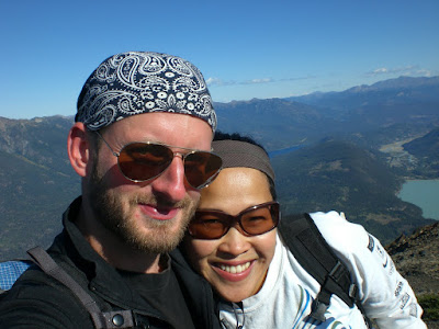
Joe and me


Before flying home I went on a little road trip out to Gun Lake where my friend has a cabin on the lake. So Lan, Erna and me drove out there on Thursday. Here along the rough gravel road known as the Hurley Pass starting from Pemberton north of Whistler.


day 3 we used to do some hiking up Green Mountain. The dark blue lake on the left is Gun Lake and the bright blue one is Downton Lake fed by a glacier river.


once we got to the peak of Green Mountain we kept on pushing further along the ridge towards the glacier


last night at Gun Lake

On the way back we took the Carpenter Lake road to Lilloet, from there the #99HWY south to Whistler and from ther to Vancouver.

On the way back we took the Carpenter Lake road to Lilloet, from there the #99HWY south to Whistler and from ther to Vancouver.
Then a day later, Monday September 28th I had to fly back home...
posted by Dönner - เดินเนอร์ - 듀너 - ドエナー - 德納 at 9:52 AM
6 comments
![]()


